LUNA
A FIELD GUIDE TO ELSEWHERE
10 STOPS

A lunar field guide / 10 coordinates

luna.

The nearest world is not a blank. It is a record — of violence, weatherless time, and the stubborn choreography of getting there.

Begin the descent
Earth’s only natural satellite 384,400 km from here
00 / 10 SCROLL TO ROTATE AN OBJECT OF MEMORY

01 Before the names

Look long enough
and the surface starts speaking.

What follows is not a checklist of achievements. It is a slow orbit through ten places where the Moon kept the evidence.

28° 32′ 03″ N
80° 39′ 00″ W

02 The descent

Ten stops.
One ancient body.

Move through the archive. The Moon follows — turning toward each coordinate, then closing the distance.

01 / 10FIRST LIGHT

Mare Tranquillitatis · Apollo 11

The first
human horizon.

On 20 July 1969, the lunar module Eagle settled into a plain of basalt that looked almost anonymous from orbit. In the grainy transmission, the horizon seemed close enough to touch — a small, bright line carrying the weight of an entire species.

Neil Armstrong and Buzz Aldrin spent 21 hours and 36 minutes on the surface. They left a flag, a camera, a seismometer, and a plaque that tried to make a permanent sentence out of a temporary visit. The footprints remain because there is no wind to erase them.
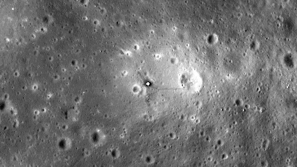
The Apollo 11 landing site in Mare Tranquillitatis photographed by Lunar Reconnaissance Orbiter
THE SITE, DECADES LATERNASA / LROC ↗
0°41′ N · 23°26′ EMARE / BASALT PLAIN
02 / 10THE FIRST SOFT LANDING

Oceanus Procellarum · Luna 9

A machine
learns the ground.

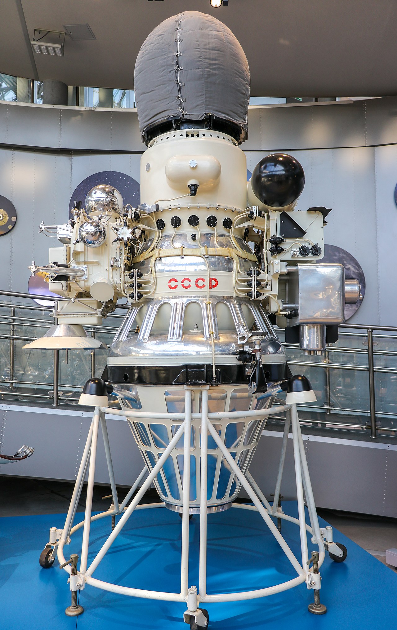
Before a boot touched the Moon, a box with four petals did. Luna 9 arrived on a rough patch of Oceanus Procellarum in February 1966, becoming the first spacecraft to land softly and survive the impact of being somewhere else.

Its panoramic images arrived line by line, translated from a world no camera had ever seen from the surface. The horizon was low. The stones were sharp. The ground held — proof that the Moon was solid enough to stand on, and strange enough to keep asking questions.

A model of the Luna 9 spacecraft, the first probe to make a soft landing on the Moon
LUNA 9 / ARCHIVAL MODELWIKIMEDIA COMMONS ↗
7°05′ N · 64°22′ WROBOTIC / SOFT LANDING
03 / 10PRECISION

Oceanus Procellarum · Apollo 12

Close enough
to touch the past.

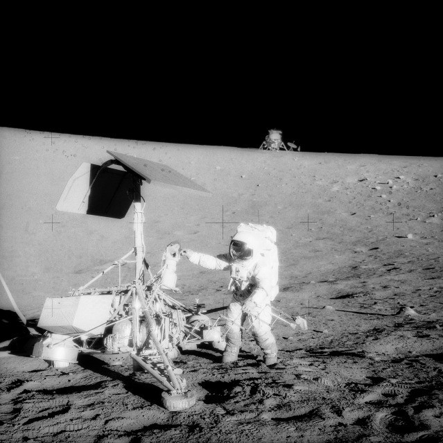
Apollo 12 landed with a kind of confidence the first mission could not afford. Intrepid came down within walking distance of Surveyor 3, the little American probe that had been waiting in the Ocean of Storms since 1967.

Charles Conrad and Alan Bean brought pieces of it home: a television camera, bits of cable, and a better answer to how materials change under years of vacuum, radiation, and micrometeorites. Exploration became less about arriving, and more about choosing exactly where to arrive.

Apollo 12 astronaut Charles Conrad examines the Surveyor 3 spacecraft on the Moon
CONRAD AND SURVEYOR 3NASA / JSC ↗
3°01′ S · 23°25′ WSAMPLE / RENDEZVOUS
04 / 10THE HIGHLANDS

Fra Mauro · Apollo 14

The Moon
keeps its scars.

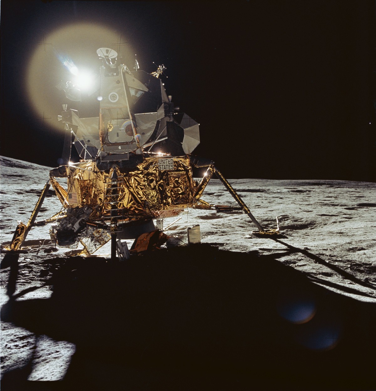
Fra Mauro is not a crater in the simple sense. It is the blanket thrown outward by the impact that made Imbrium — a landscape assembled from the Moon’s own broken interior, then left to harden in silence.

Alan Shepard and Edgar Mitchell climbed through the debris with a handcart, searching for material old enough to tell the age of the basin beneath them. Their traverse was only a few kilometers, but every step moved through deep time: impact, melt, cooling, dust.

The Apollo 14 lunar module Antares standing in the Fra Mauro region
ANTARES AT FRA MAURONASA / JSC ↗
3°38′ S · 17°28′ WIMPACT EJECTA / HIGHLANDS
05 / 10THE LONG DRIVE

Hadley–Apennine · Apollo 15

Go where the
mountains begin.

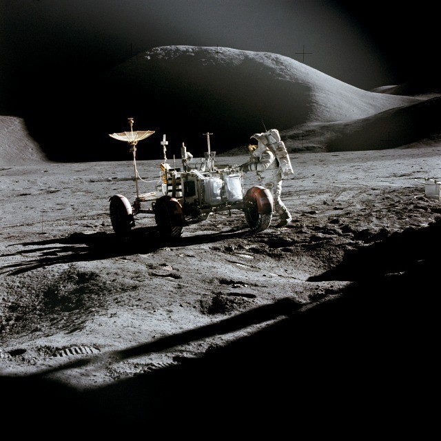
Apollo 15 was the moment the Moon opened up. The Lunar Roving Vehicle carried David Scott and James Irwin away from the landing site, across lava plains toward the Apennine front and the deep, sinuous cut of Hadley Rille.

They collected basalt that had flowed from a lunar volcano, sampled a rock lifted from the mountains, and left a tiny package of instruments listening for quakes. With the rover, the surface became a field site instead of a stage — distance turned into evidence.

Apollo 15 astronaut James Irwin working beside the lunar rover at Hadley-Apennine
JAMES IRWIN / LRVNASA / JSC ↗
26°07′ N · 3°38′ EROVER / VOLCANIC BASALT
06 / 10THE ANOMALY

Descartes Highlands · Apollo 16

A place that
refused the theory.

From orbit, the highlands looked volcanic. On the ground, the story changed. Apollo 16’s crew found breccias and impact-shocked rock where the old maps had promised fresh lava — the Moon quietly correcting its visitors.

John Young and Charles Duke drove farther than any crew before them, sampling a pale, rugged terrain that preserves the Moon’s earliest crust. The mission’s most valuable instrument was its willingness to be surprised.

The Apollo 16 lunar surface experiments package deployed in the Descartes Highlands
APOLLO 16 / ALSEPNASA / COMMONS ↗
8°58′ N · 15°30′ EANORTHOSITE / BRECCIA
07 / 10THE LAST FOOTSTEPS

Taurus–Littrow · Apollo 17

The valley
holds the light.

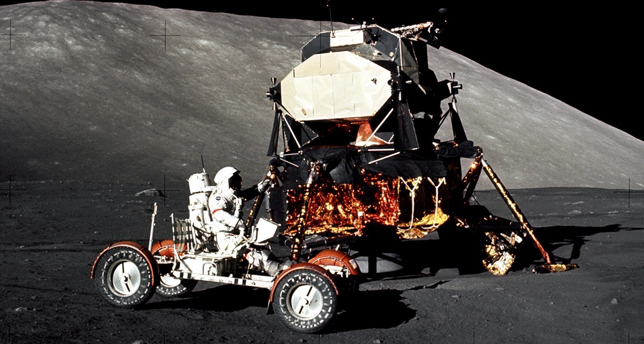
At Taurus–Littrow, Apollo 17 found a valley framed by mountains and split by a dark seam of ancient lava. Harrison Schmitt — the only professional geologist to walk on the Moon — recognized orange soil spilling from a volcanic vent.

Eugene Cernan’s last bootprint crossed the dust on 14 December 1972. The mission left behind a rover, a gravimeter, a flag, and a question that still glows: how much of the Moon’s interior once moved like fire?

Apollo 17 commander Eugene Cernan driving the lunar rover in Taurus-Littrow
GENE CERNAN / LUNAR ROVERNASA / HARRISON SCHMITT ↗
20°11′ N · 30°46′ EVOLCANIC GLASS / LAST EVA
08 / 10THE MOUNTAIN MADE IN A SECOND

Tycho · Central Peak

A crater that
built its own summit.

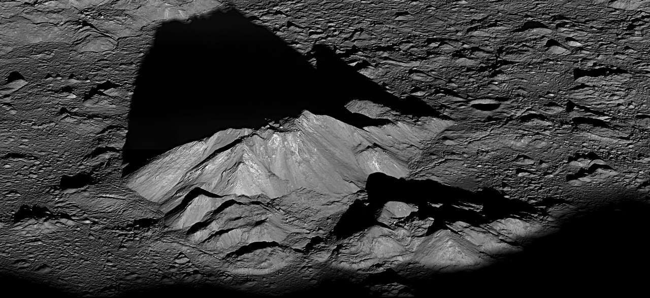
Tycho is a wound with architecture. An impact excavated the southern highlands and threw bright rays across the near side; at the center, the crust rebounded into a mountain almost two kilometers high.

Lunar Reconnaissance Orbiter sees the peak in a clarity the astronauts never had — boulders, terraces, melt pools, and shadows that stretch like ink. It is a reminder that the Moon’s most dramatic landscapes were often made in an instant, then kept forever.

The central peak of Tycho crater seen by the Lunar Reconnaissance Orbiter
TYCHO CENTRAL PEAK / LROCNASA / GSFC / ASU ↗
43°18′ S · 11°12′ WIMPACT / CENTRAL UPLIFT
09 / 10THE COLD TRAP

Shackleton Crater · South Pole

Somewhere between
sun and shadow.

Near the south pole, the Moon turns its horizon into an instrument. Shackleton’s rim catches nearly continuous sunlight while its floor sits in a darkness that has barely changed in billions of years.

Those permanently shadowed pockets may hold water ice — not as a lake, but as molecules preserved in the cold. The pole is at once ancient and strategic: a climate archive, a navigation problem, and the next place humans are learning how to arrive.

A topographic view of Shackleton crater at the lunar south pole
SHACKLETON CRATER / SOUTH POLENASA / GSFC / ASU ↗
89°54′ S · 0°00′ EICE / PERMANENT SHADOW
10 / 10A NEW SOUTH

Statio Shiv Shakti · Chandrayaan-3

The map is
still being drawn.

On 23 August 2023, India’s Vikram lander came down near the Moon’s south-polar region — a soft landing after the world had watched another attempt fall silent. The site, later named Statio Shiv Shakti, is now a coordinate in a new era of lunar exploration.

Its Pragyan rover moved through a landscape no person has yet crossed, measuring the soil and the chemistry of the near-pole. The old archive is opening again, this time with more nations, more instruments, and a longer horizon.

The Vikram lander photographed on the lunar surface by the Pragyan rover
VIKRAM / FROM PRAGYANISRO / GODL-INDIA ↗
69°22′ S · 32°19′ EROVER / SOUTH POLAR REGION

03 After the last coordinate

There is no
elsewhere without here.

Luna is close enough to remember and far enough to remain strange. The next footprint will not erase the first ten. It will add another line.

Return to orbit
LUNA / A FIELD GUIDE TO ELSEWHERETHE END, FOR NOW